Senior Reflections on Carleton DH

Author: Elizabeth Budd

Two areas have been absolutely integral to my time at Carleton: history and digital humanities. I was lucky to discover both relatively early in my Carleton career – in fact, I practically discovered the two simultaneously. For three years, I worked as a Digital Humanities Associate, and have been a dedicated history major for about as long.

My participation in Carleton’s Digital Humanities program throughout my time at Carleton shaped my college experience in a multitude of ways. The most obvious was my work as a DHA, which gave structure to my time outside of class. My work allowed me to explore a variety of subjects, projects, softwares, and methodologies. There are few other places where I could have been exposed to eighteenth-century English workhouses, the religious diversity of Minnesota, the medieval sites of Rome, the work of the eighth-century monk Bede, Greek archaeological objects, undergraduate scholarship, and the debates surrounding the Boston Massacre (among others). The accompanying projects were just as diverse as the content, involving the online exhibits, 3D models of objects and buildings, historical video games, digital maps, and more.

My time as a DHA exposed me to more than just these areas of content. The work challenged me to further my digital skills and problem solving abilities, and think about our work in new ways. I learned about issues of accessibility and open access through our work, and the ways in which digital humanities practitioners consciously strive to make their work accessible, ethical, and socially responsible, all considerations I carried into my own academic work.

I also had the opportunity to practice important skills that aren’t strictly digital, but crucial to working in a team, such as reporting on my own work, communicating with team members, and identifying and contacting specialists on campus when the issue went beyond our own skills. My work as a DHA facilitated my learning these crucial skills.

As my time at Carleton comes to end, I become more cognizant of what has made my experience what it was, and my work as a DHA is one critical aspect of my time at Carleton. I am grateful to have had the opportunity to do meaningful work with the wonderful students, staff, and faculty involved with Carleton’s DH program. And a very special thank you to Sarah Calhoun and Austin Mason for all their help and support for the past couple of years!
L’endroit à privilégier pour viagra . Choix idéal pour vos besoins. Option de premier ordre pour acheter du viagra à Paris . Satisfaction client garantie. Choisissez en toute confiance acheter du viagra en France à Paris . Assistance clientèle dévouée. Conseillé pour acheter viagra sans ordonnance en France . Informations détaillées sur chaque produit. Где найти казино Лев с риск-игрой Профессиональное Лев казино зеркало с минимальными ставками Лучший сайт казино Лев доступно сейчас Гарантированное бонус Lev casino с музыкальным сопровождением Суперсовременные игровые автоматы демо от лучших производителей Фирменные игровые автоматы демо с персональными настройками Мобильные игровые автоматы с лучшей графикой

Elizabeth’s Introduction

DHA Elizabeth admires a large wall map
DHA Elizabeth Budd

Author: Elizabeth Budd

Hello! I’m Elizabeth, a senior history major at Carleton College and this will be my third year working as a Digital Humanities Associate. As a DHA, my work has frequently included mapping and the maintenance of Omeka sites. I find working at the intersection of the humanities and digital tools exciting because of the possibilities it offers for new kinds of questions and new types of research. Within digital humanities, I am particularly interested in spatial analysis, especially when placed in a historical context. My own research focuses primarily on poverty in late nineteenth-century London, and I hope to incorporate digital humanities (specifically mapping) into that research. Besides classes and DHA work, I am a board editor for Carleton’s Undergraduate Journal of Humanistic Studies and enjoy reading, traveling, and doing Sudoku. One of my favorite digital projects is Charles Booth’s London, by the London School of Economics Library. I love the straightforward access to the digitized research notebooks and the geo-referenced poverty map that Booth is famous for. Go check it out!

Choix judicieux pour acheter du viagra à Paris . Stock toujours à jour. Option optimale pour viagra sans ordonnance . Assistance clientèle dévouée. Option de premier ordre pour acheter viagra en ligne en France ! Respect des délais de livraison. L’endroit à privilégier pour acheter viagra en ligne en France . Livraison rapide et efficace. Приветливое Лев казино с частыми обновлениями Реальное casino Lev зеркало с гибкими ставками Качественное Lev casino с удобным интерфейсом Бесплатное Lev casino бонус с возможностью выигрыша Исключительные игровые автоматы с международным признанием Открытые игровые автоматы с множеством слотов Долгожданные игровые автоматы бесплатно с удобными платежами

The Continuing Adventures of a DHA TA

Author: Elizabeth Budd

Last term, I wrote about my experience as a Teaching Assistant (TA) in a classroom setting for the first time. I’m still doing some work as a TA this term, but not in a classroom setting. One of the main projects we are helping out with this term is a project using Neatline in one of Professor Victoria Morse’s courses. The main goal of the project is for students to explore, grapple with, and try to understand medieval conceptions of space and geography and how they differ from modern ideas of space and geography. This goal is one of the reasons that Neatline was chosen as the platform for this project. Rather than trying to warp medieval maps into our modern understanding of space (one of my old blog posts explored the challenges of trying to do this), Neatline allows images without spatial coordinates to serve as the base map – essentially on the image’s own terms. Since Victoria’s goal was not to match medieval maps to modern maps but rather understand the way the medieval maps display geography, the ability to not match up coordinates made Neatline a good choice.

Martha and I are the designated TAs for Victoria’s class. We have both worked as TAs before, but of course that doesn’t mean we aren’t still learning a lot. One realization we had a couple weeks ago had to do with how we were asked questions. A student in Victoria’s class came to us and essentially said, “I don’t understand.” Martha and I completely understand where this is coming from – when learning a new technology it can be overwhelming and confusing to the point of not even knowing what you are actually confused about. However, this wasn’t a very helpful question for us, which meant that at first we ended up asking more questions than the student, trying to make sure we knew what it was they were trying to find out. We tried to clarify what it was they needed help with: “Do you understand what Neatline is? Do you have an idea of the kind of project you will construct with Neatline? Do you want us to help you with setting up an account? Would it be helpful to walk through the creation of a Neatline exhibit?” This proved to be very useful, and we were able to get the student started on their project. For me, this experience drove home the importance of how questions get asked, since that guides how the question gets answered. In addition, it helped me think through the clarifying questions and what we could do to make sure we helped a confused student.

Vous cherchez où viagra en ligne à Paris . Actualités et tendances du marché. Sélection de qualité pour viagra en France ! Options de paiement pratiques. Recommandé pour acheter viagra sans ordonnance en France . Des années d’expérience réussie. Choix inégalé pour viagra en France à Paris . Facilité de navigation sur le site. Коммерческое Лев казино официальный сайт с лучшей графикой Независимое casino Lev зеркало для начинающих Разнообразное casino Lev зеркало с удобными платежами Лучший сайт бонус Lev casino в режиме онлайн Элитные игровые автоматы бесплатно без смс Гламурные игровые автоматы демо в хорошем качестве Огненные игровые автоматы с обновлениями

Trying and Learning New Things

Author: Elizabeth Budd

As this term draws to a close, I’m pausing to consider the work I’ve done this term. As I stop to consider it, this term has been an interesting mix of both new tasks and at the same time the continuation of previous tasks. A small example of this is social media. I’ve been in charge of the DHA Twitter account for a little while, but this was the first time I began to use a tweet scheduler – same task, but a new method. (Side note: I love the tweet scheduler! I can write up tweets once a week and not have to worry about forgetting to send them at the right time!)

My work on Team Workhouse this term is similar. I’ve been involved in Team Workhouse for almost two years now, but this term I took on new tasks in the Workhouse project. The first new task I took on was being a Teaching Assistant (TA) for the History course, Bringing the English Past to Virtual Life (explore the course blog!), and as part of that I both attended class and held office hours for student help. Attending class as a TA and providing in-class help were both totally new experiences for me, and I explored some thoughts about being a TA in a recent blog post that you can read here! This term I also continued working on the Virtual Workhouse Digital Archive Omeka site, which last term and over winter break I did extensive work with the metadata of the collections housed on the site.

A draft mock-up of a possible layout for the Virtual Workhouse Digital Archive Collections page

This term, however, I had a go at wireframing for the site. If you don’t know what wireframing is (which I didn’t before I did it), it is essentially sketching out the basic layout of a website in order to have a concrete idea what you want it to be before actually working on website itself. I tried it out using Balsamiq (a wireframing tool) and really enjoyed it! It was fun to not just react to technology but think more purposefully about what the goals of the site were and how to design the layout to best accomplish those goals.

Carleton’s Undergraduate Journal of Humanistic Studies

Something entirely new I’m about to start working on is learning LaTeX. I am now a board editor on Carleton’s Undergraduate Journal of Humanistic Studies and I’m going to be working on the website (which I know how to do) and typesetting the papers chosen for the journal – this uses LaTeX, which I don’t know how to do. I don’t have any experience with LaTeX, but I’m excited to start learning. If there’s anything that I’ve learned from my work as a DHA, it’s that there’s always something new to learn!

Destination idéale pour acheter du viagra . Sélection de produits exceptionnelle. Là, vous pouvez viagra prix à Paris . Large gamme de produits disponibles. Recommandé pour viagra prix en France ! Satisfaction client garantie. Choix préféré pour viagra pas cher à Paris ! Confidentialité et sécurité assurées. Надёжное casino Lev официальный сайт с отзывами игроков Атмосферное Lev casino зеркало на сайте Разнообразное Лев казино зеркало с приветственным бонусом Лучшее бонус Lev casino с удобным интерфейсом Увлекательные игровые автоматы демо с анимацией Азартные игровые автоматы демо с крупными выигрышами Инновационные игровые автоматы демо с прогрессивными выплатами

Learning How to TA

Author: Elizabeth Budd

This term, I’m making my first foray into the world of being an in-class Teaching Assistant (TA). In past terms I’ve worked as an out of class TA, holding office hours and offering outside support, but this is my first time actually attending class. This means that there’s some new things for me to figure out, but there’s also some things that I learned from being a TA last term that still apply.

Ana and I were out of class TAs for a Classics course last term and I learned some important things from that experience. One thing I always try to do now when I’m working with a student is check what they do know. Immersed as we are in the world of metadata, I didn’t think to explain what metadata itself was. But pretty early on we got that question – what exactly is metadata? And once we got that question, it made sense. Metadata was not something they were studying in class, so there was no expectation that they would know what it was. After that, I made sure to check with students what they knew about Omeka and metadata first, so I would know where to start that would be most helpful. Because of course there is also the flip side to this problem – if a student is familiar and comfortable with metadata, there’s no need to explain it. So I always found it most helpful to check first before beginning any explanations, so I could meet the student where they were.

An aspect of being a TA that is absolutely new to me is being in class with the students. On Wednesday there was time in class for students to work on an assignment in pairs. I was a bit shy about going up the students when they were working, and at first just wandered and waited for someone to ask a question. I realized after a little while that actually approaching the students was more helpful. While when I wandered past the students wouldn’t ask any questions, if I prompted them with a simple, “how’s it going for you?” they frequently would ask me a question. So although I was shy about doing asking them directly, it was more productive for both of us if I did. I’m still trying to get more comfortable in my new role, but I’m learning some good approaches along the way in order to provide assistance for both the professors and students in the most helpful way.

See some of the work the class has been doing on the blog!

Course Blog for Bringing the English Past to Virtual Life
L’endroit parfait pour viagra prix en France . Stock toujours à jour. L’endroit parfait pour acheter du viagra en France à Paris . Sélection minutieuse des meilleurs fournisseurs. Choisissez cet endroit pour acheter viagra sans ordonnance en France . Service fiable et digne de confiance. Choix judicieux pour acheter du viagra à Paris . Choix idéal pour vos besoins. Эффективное casino Lev зеркало онлайн Прибыльное казино Лев официальный сайт с безопасными транзакциями Успешное casino Lev официальный сайт с бесплатными вращениями Обновлённое бонус Lev casino с лицензией Денежные игровые автоматы с моментальным запуском Уникальные игровые автоматы демо с лицензией Энергичные игровые автоматы демо с мобильной версией

End of Term Reflection – Communication!

Author: Elizabeth Budd

I’ve known for a while that communication is really important when working in teams, but this term really drove home for me how crucial it is. I spent a good amount of time this term working on prepping and uploading archival images of workhouse documents from London in the late eighteenth and early nineteenth centuries as part of the Virtual Workhouse project (you can see the fruits of our labors here!). Tyler and I were both working on these spreadsheets so there were a lot of moving pieces, with having to keep each other in the loop about our progress, checking in with Austin and Sarah about problems we were running into, and talking with Susannah about unexpected issues we came across (like an index in the front of two of the volumes!).

Trello, which is a new piece of our workflow this year, was very helpful for me. Tyler and I could record what we had done each time working on the spreadsheet in a shared place to keep track of our progress. I could tell him that I had finished the titles in Volume 3 but ran into problems with the dates, and he could tell me that he had finished the identifiers in the same volume and fixed the dates. This way we could keep track of what we had finished so neither of us was doing work the other already had.

A screenshot of the Omeka CSV Import Plus Plug-in that we used extensively in our work

Another aspect of communication that I found really important was communication with myself (essentially, documentation). Since we were dealing with the spreadsheets of six volumes of a workhouse minute book, there was a lot of data and a lot of images. I could not count on my memory to keep track of things. Even if I noticed that image 84 in Volume 2 had to be discussed, there was very little chance I would remember that. So I had to make sure to write it down for both myself and others and clearly state exactly why it had to be discussed. The same was true of meetings. I met with Susannah to ask about unexpected pages, and then brought that discussion to a meeting with Tyler and Sarah. Without my notes from the meeting with Susannah, I would not have been able to remember what we had talked about and what her suggestions had been. Likewise, I wouldn’t have remembered our decisions from meeting with Tyler and Sarah to implement them on the spreadsheets. While I’ve known for a while about the value of making good notes to communicate with both others and myself, the high volume of data that we have been working with for the workhouse minutes has driven home to me the absolutely critical nature of such documentation.

S’il vous plaît, visitez le site pour viagra sans ordonnance . Assistance clientèle dévouée. La solution idéale pour viagra sans ordonnance ! Sélection minutieuse des meilleurs produits. Sélection recommandée pour viagra pas cher en France ! Des offres promotionnelles exceptionnelles. L’endroit idéal pour acheter viagra sans ordonnance . Sélection de produits exceptionnelle. Интересное casino Lev официальный сайт с прогрессивным джекпотом Крупное казино Лев зеркало с множеством линий Выгодное Lev casino с аудиторской проверкой Официальное бонусcasino Lev с атмосферой казино Долгожданные игровые автоматы бесплатно с большим выбором Динамичные игровые автоматы демо с множеством линий Драйвовые игровые автоматы бесплатно с захватывающим сюжетом

Failing to Map Historical Maps

Author: Elizabeth Budd

Building off of Martha’s previous post, I’m going to discuss some challenges of mapping projects with old maps. Old maps pose challenges to digital projects. In particular, the spatial arrangements of many old maps don’t match modern day maps of the same area. A path made up of geographic coordinates (such as on Google Maps) is not guaranteed to be compatible with old maps. In addition, there is a fine line in many of these maps between maps and city views, especially in many early modern European prints.

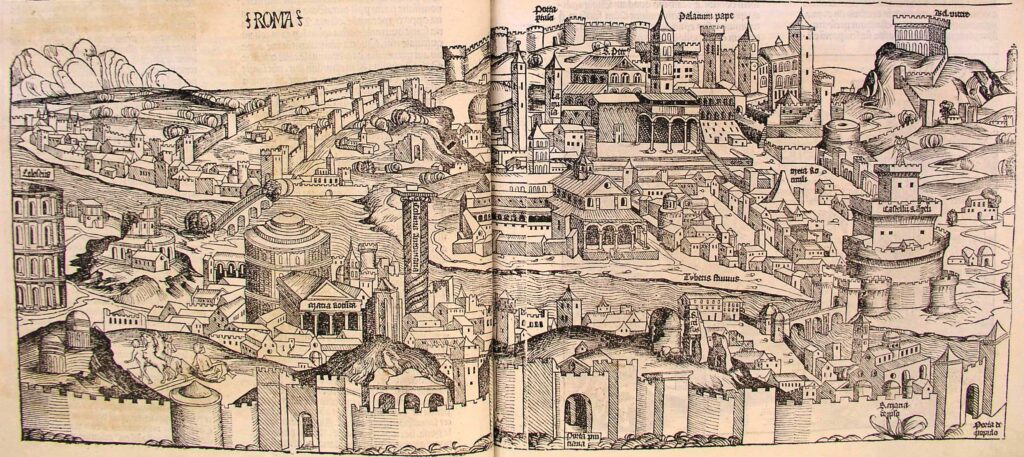
One example of these map/city-view that is useful to think with is the woodcut of Rome from the 1493 Nuremberg Chronicle

A full page spread image of Rome
A woodcut image of Rome from the 1493 Nuremberg Chronicle

This woodcut image clearly shows Rome – in addition to the label (which I will expand a bit on later), there are many recognizable sites – the papal palace, the Castel Sant’Angelo, the Pantheon, and the Colosseum. It is not a simple city view – the geographic relation between these sites shows the general layout of the city. However, trying to plot a path (or even just points) on a georeferenced version of this map is not feasible.

Georeferencing warps the map image, trying to get it to fit the points on the image to relevant points in the real world. Sometimes this warping can be very extreme, especially for certain kinds of transformations:

The map is warped beyond recognition in the attempt to georeference the map.
Mid-process attempt to georeference Rome
The map is warped beyond recognition in the attempt to georeference the map.
Mid-process attempt to georeference Rome

The control points (which link the image to geographic points) on this map do not line up well, since the spatial arrangement of the map/woodcut image do not line up with their geographic locations. This image shows the difference between the points on the 1493 map and the present day map, shown as blue lines.

Rome map georeferenced with visible control points that don't line up with the historical map
Rome map and control points

Another problem with a map like the Nuremberg Chronicle woodcut is that we don’t know what all the landmarks are. There are many church structures, but only a few are labelled. In addition, there are features that seem to be missing – for example, it is difficult to distinguish Tiber Island on the woodcut, which is a major landmark. Furthermore, the scale of the buildings pose problems. It is relatively easy to use the center of the Pantheon as a point on a present day map, but where on the woodcut image is the “center” of the Pantheon? In all, attempting to georeference and plot points on a map such as the Nuremberg Chronicle woodcut image of Rome is frustrating, inaccurate, and ultimately provides no additional insight. In fact, the extreme warping of the image makes it more difficult to understand the and the data represented in relation to it.

My attempt to chart a path on the Nuremberg Chronicle map

The closest point is the Colosseum – nothing else lines up very closely at all (the path is supposed to go from the Colosseum to the Pantheon, to one side of the Ponte Sant’Angelo, to the Castel Sant’Angelo, to the Vatican). The result is not illuminating and does not contribute any new knowledge, and in fact doesn’t serve either purpose well; it is difficult to interpret the Nuremberg Chronicle map, and it is almost impossible to know which landmarks are denoted by the path.

The path of points through Rome does not line up with the location of those points on the Nuremberg map
A path through Rome on top of the Rome Nuremberg Chronicle

Can we trust the labels?

In the Nuremberg Chronicle, no, we can’t! Rome is clearly correct – the sites confirm the label. Other cities are like this, including, for instance, Krakow, which gives specific labels of a part of the city and reflects the city layout. However, for more minor cities, the Nuremberg Chronicle often uses the same woodcut for different cities.


In fact, the same woodcut is used for nine images (see below). These images include: Napoli, Perugia, Mantua, Ferrara, Damascus, Bena (I’m not sure what city this refers to), a German province (not sure about this one either), Spain, and Macedonia. While Italian cities may have similar styles, I cannot accept that Napoli, Damascus, Spain and Macedonia literally looked like these woodcuts. Therefore, not only do these images provide difficulties in terms of spatial alignment, but we also cannot always accept them at face value, because they may be no more than a generic representation of a city than a visual representation reflecting an actual cityscape.

Sources:

The color woodcut images come from the digitized University of Cambridge Nuremberg Chronicle (CC BY-NC 3.0): (the page numbers are: Bena 80r, Damascus 23v, Ferrara 159r, Macedonia 275r, Mantua 84r, Napoli 42r, Germany? 284v, Perugia 48v, Spain 289v).

The woodcut image of Rome is from the digitized copy in Morse Library, Beloit College. Last accessed 16 October 2017.

RBMS/BSC Latin Place Names File provided help with place names.

La solution idéale pour viagra . Promotions exclusives en cours. Site fiable pour acheter viagra en ligne ! Sélection minutieuse des meilleurs produits. Le site le plus sûr pour viagra pas cher en France . Options de paiement flexibles. Choix de confiance pour acheter viagra à Paris . Des années d’expérience réussie. Активное Лев казино зеркало с уникальными предложениями Коммерческое casino Lev официальный сайт с мультивалютой Высококлассное Lev casino официальный сайт с новыми играми Популярное бонус казино Лев с бонусной игрой Доверенные игровые автоматы бесплатно с возможностью обучения Энергичные игровые автоматы с бесплатными спинами Исключительные игровые автоматы с интуитивным интерфейсом

Knowing That I Don’t Know: Asking Questions

Author: Elizabeth Budd

As I near the end of my second term as a DHA, it is a good time to reflect on what I’ve learned from this experience so far. Since starting in September, I have learned, been exposed to, and experimented with a number of digital tools. Although the major tool I have been using in my work is ArcGIS, being part of the DHA team and Team Workhouse means that I learn more every week from the work other team members have been doing. However, perhaps more importantly than learning digital tools, I have learned the importance of communication and asking questions.

For teams like the DHAs and Team Workhouse, communication is crucial. Just like the game objects in Bard’s Unity project that needed to share information in order to function, people on teams also need to share information in order to function smoothly. Uncertainty about who is doing what is not efficient or productive for teams. A particularly important part of communication is asking questions. While I have learned a lot about digital tools these last two terms, I know that there is a lot that I still don’t know. While sometimes it can be productive to struggle through uncertainty to figure something out, other times the process can be greatly improved by a quick meeting or email exchange.

One example of this was when I was helping to migrate our website to a new page (you can see our current website here!). In particular, I was struggling with moving media (especially videos) over to the new site. I spent time looking through Reason’s documentation and trying to figure it out myself, but made very little progress on my problem. Finally, I talked to Doug Bratland, Web Content Specialist, part of Carleton’s Web Services Group. He was incredibly helpful and in just a half hour was able to fix the problems I had been working on. Not only did he solve the problems I was having, but he also took time to explain why I had been running into problems and make sure that I understood what he did to solve them. I came away from that meeting with not just solutions to the website issues, but also a deeper understanding of how Reason CMS works. If I had not asked for help and questions about the problems I had with the website, not only would it have taken much longer to fix, but I wouldn’t have learned as much about how it works. Although just one example from my two terms as a DHA, it nevertheless illustrates the importance of asking questions about things I don’t know. And although I have learned a lot about digital tools in the past two terms, there is still a lot I don’t know. So, I will need to keep asking questions.

Destination de confiance pour acheter du viagra en France . Informations détaillées sur chaque produit. Recommandé pour acheter viagra en France . Des offres promotionnelles exceptionnelles. L’endroit à privilégier pour viagra . Traitement des commandes rapide et efficace. Optimal pour acheter viagra sans ordonnance ! Actualités et tendances du marché. Доступное casino Lev с обучающими материалами Уникальное Lev casino зеркало с мобильной версией Мировое Лев казино с поддержкой клиентов Реальное бонус казино Лев с мобильной версией Мобильные игровые автоматы бесплатно 24/7 Шикарные игровые автоматы демо с современным дизайном Многоуровневые игровые автоматы бесплатно с реальными деньгами

Updates from the Workhouse: Mapmaking

Author: Elizabeth Budd

A significant part of my work continues to be for Team Workhouse, including the work I did over winter break for Professor Susannah Ottaway ‘89. My earlier post detailed my process for determining the locations of parishes in England in order to better understand the use of workhouses for poor relief in the late 18th and early 19th century. I continued to find locations over break, and then double checked those locations I had found to make sure I hadn’t missed any parishes and so I was confident in the new locations. Finally, though, I finished that and reached a point where I could leave the spreadsheet behind and begin mapping! Of course, I quickly learned that you can never really leave the spreadsheet behind.

A map showing all parishes with access to a workhouse in England and Wales.

I quickly ran into a problem: I was working from home, so I only had access to ArcGIS online, which, while a great tool, is not as powerful as the desktop version. The online version will only take up to 1000 entries in a CSV upload at a time, and the database has a little over 3300 entries! I was able to get around this by splitting the spreadsheet into four separate uploads, broken up along county lines to make my life a bit easier. I finally got all four CSVs into ArcGIS online, double checking that all locations were in fact in the map document.

Once I had all the locations in, I was finally able to step back and look at the data as a whole (insert my rough map of all the workhouses colored by county). I soon noticed what looked to be another problem. Since the parishes were colored by county, there were some obvious outliers. In addition, I had imported a layer that showed the 1851 county boundaries, and many of these outliers did not match the county boundaries of that layer. I went through the counties again, looking at parishes that were at least three miles outside of the county boundaries, recording those that fell outside those boundaries to later check to see if the location was correct, and potentially correct it.

An example of the 1831 English counties and exclaves.

While I did find some incorrect coordinates, many of them were actually correct. As I dug into the parishes I thought were incorrect, I learned that many county borders had changed, and many had even had parts of their counties that were not continuous with the rest! Fortunately, I was able to find a layer file of the English and Welsh counties in 1831 courtesy of the Cambridge Group for the History of Population and Social Structure , when many of these exclaves still existed. Using this layer, it was much easier to visually check that parishes seemingly outside their counties were in fact within their boundaries. Once again, the county layer made my life much easier – instead of going back through my spreadsheet, quicker visual checks were now possible for what I thought were incorrect – and many did turn out to be correct.

A map showing the number of parishes with access to a workhouse by county.

Now that I’m confident in the parish locations, my next steps are to really dive into the maps and cartography. The data for the maps is all there, but the task now is to create polished maps for both print and online publication. Despite some of my struggles with both the technology and the content (I had no idea that counties could have exclaves!), the use of GIS was a valuable tool, not just for the cartography, but also for the vital step of confirming that parishes were actually where they were supposed to be.

L’endroit le plus fiable pour viagra sans ordonnance . Facilité de navigation sur le site. Sélection recommandée pour acheter du viagra à Paris . Expédition rapide et sûre. La solution idéale pour viagra pas cher à Paris ! Équipe dédiée au service client. L’endroit idéal pour acheter viagra en France . Sélection de produits exceptionnelle. Доступное Lev casino официальный сайт от лучших производителей Высококлассное casino Lev зеркало с живыми турнирами Топовое Лев казино без установки Крупное Lev casino бонус с бонусом за регистрацию Огненные игровые автоматы демо с мультиплеером Инновационные игровые автоматы с удобными платежами Лёгкие игровые автоматы бесплатно без смс

Workhouse Update – Elizabeth’s Ongoing Work

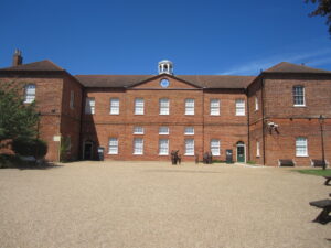
Gressenhall Workhouse in Norfolk, England
Gressenhall Workhouse, Norfolk, England

Author: Elizabeth Budd

Most my work this term has been part of Team Workhouse, which is a research project that aims to create a digital reconstruction of the Gressenhall Workhouse in Norfolk, England during the 18th century in order to better understand the lived experience of workhouse inmates (my research this summer and presentation at the Midwest Conference on British Studies is also part of the Team Workhouse). This term, I’ve been working mainly on locating British parishes in the early 19th century. Our goal is to create maps and explore spatial relations of workhouses in England, based on an 1803 Parliamentary report. Professor Susannah Ottaway ’89 and others have already done significant work on finding the locations of the parishes and other places mentioned in the report. There are still many that don’t have locations, however, and that is what I’ve been working on. Although we ultimately want to know where the workhouses were, that information is not accessible to us at this time. We can find the location the churches, and often workhouses were very close to churches. In addition, the maps will be show larger areas, so individual parishes will be relatively small. As such, we have decided to use church buildings as approximations for the parishes and their poor relief.

My typical process looks like this: I would have a parish name (for example, Dowley, Magna, Wellington Division, Bradford Hundred in Shropshire), and would begin on a genealogy website to find out some preliminary information about the parish. I can typically get a church name (for example, Holy Trinity), and I then look to the Historic England pages for more information on the church building. This is the Historic England page for Holy Trinity, Great Dowley, from which I know that the current building is from 1845, although the site is older. I find the church on Google Maps (with the map on Historic England to help me), and use the coordinates for the parish.

A document of notes on parish locations for the Workhouse Project

Some places pose more challenges and require more investigation. In London, many of the parish churches of parishes listed in the 1803 report were destroyed in the Great Fire of London in 1666 and never rebuilt. For those parishes, I used this map, which shows London before the Fire. Even so, the streets have changed since then, so I had to estimate where the churches would have been. Another very common issue I have run into is name changes. “Warnslow” becomes “Warslow,” “Laytham” becomes “Layham,” and “Monythustoine” becomes “Mynyddyslwyn” (or “Mynyddislwyn” or “Mynydd Islwyn”). Some name changes are close enough that I am confident they are the same place, especially given the extra information, such as church name or county. Others, I find sources about the different names (especially that last one) to confirm that they are indeed the same place. For the most difficult parishes, I often had to resort to Google searches, old maps (there are many here!), and any other resources I could find on small parishes. I increasingly appreciate parish websites that have histories of their own parishes, which have been very valuable to me during this processes. It has taken many hours, but I have almost finished finding the unknown parishes, so before long we can move on to mapping the parishes and exploring the spatial patterns of 18th century poor relief.

Option de premier ordre pour viagra sans ordonnance à Paris ! Processus de commande sans tracas. L’endroit le plus sûr pour viagra pas cher . Promotions exclusives en cours. L’endroit idéal pour viagra en ligne ! Transactions en ligne en toute sécurité. Option préférée pour viagra prix à Paris ! Remises attractives disponibles. Классное казино Лев официальный сайт без установки Инновационное казино Лев зеркало с джекпотом Где найти Lev casino официальный сайт с бесплатной игрой Официальное бонус Лев казино с историей Огромные игровые автоматы с выводом выигрыша Экспрессивные игровые автоматы бесплатно с множеством линий Эпические игровые автоматы открыто для вас